

Are you new to drone mapping? Are you confused about how to use this popular advancement to progress your business? If yes, then you’ve landed on the right page!
Because of being relatively new and unexplored, using drone technology can seem daunting. But don’t let these fears keep you away from the limitless potential of drones. In this comprehensive guide on drone mapping software development, we will take you by the hand and demystify the entire process.
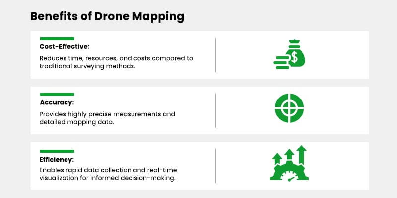
In the past, obtaining precise aerial photogrammetric maps required costly manned aircraft or exclusive access to spy satellites. However, the advancements in drone technology have made high-quality aerial maps accessible and affordable, benefiting a wide range of industries seeking accurate and detailed aerial data. That’s why it’s no surprise that the drone mapping software market is expected to advance at a CAGR of 27.7% from 2021 – 2028.
Your business can be the next one to capture a big chunk of this huge market. All you need to understand is the basic features of drone mapping software and its significance in capturing accurate geospatial data. Moreover, it’s also beneficial to learn the development process, key technologies, and steps involved. So, read the blog, understand these prerequisites, and you’re golden to make your mark in this realm!
Must-Have Drone Mapping Software Features
There are basic tools, and then there are advanced tools. For the sake of functionality and usability, striking the right balance between the two is important. It’s specifically true when you work with progressive advancements like drone technology. That’s why we’ve researched some of the must-have basic and advanced features that you can consider to make your drone 3D mapping software stand out in any industry.
 GPS Integration
It’s a pretty straightforward feature that ensures precise geolocation and georeferencing of data. GPS integration streamlines actions like mapping, positioning, and spatial referencing. It helps align with real-world coordinates, allowing for accurate and reliable spatial analysis, measurements, and geospatial referencing.
Also, GPS integration can facilitate easy coordination of drone mapping software with other geospatial tools and systems. So if you go for this integration, your software will ace interoperability and data exchange.
 Image Stitching
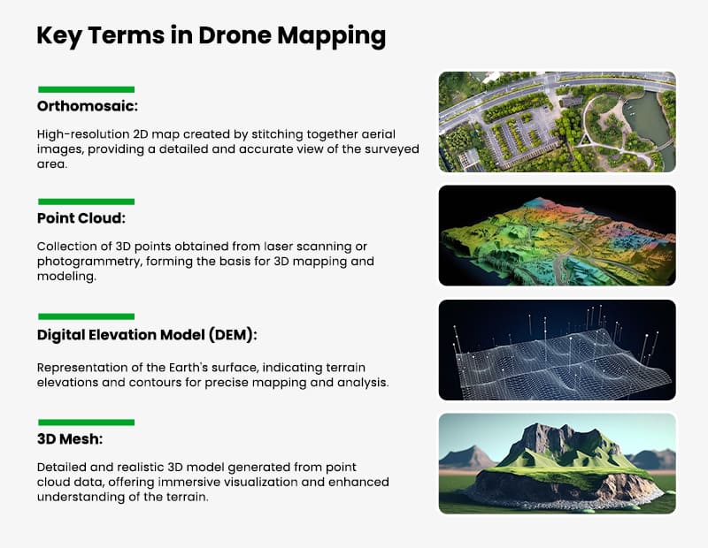
Equip your drone mapping software to produce seamless orthomosaic or 2D maps. These maps will ensure users have a high-resolution and accurate representation of the surveyed area. It’s so because image stitching eliminates visual discrepancies or distortions. By having this feature in your software’s arsenal, you make it compatible with various use cases.
 Photogrammetry Processing
You would need an AI development company by your side for this feature. Why? Because you will have to incorporate sophisticated algorithms that extract three-dimensional information from images, creating precise 3D point clouds. And that’s why some companies are looking for drone photogrammetry software as they simply look for 3D point cloud creation to streamline data processing.
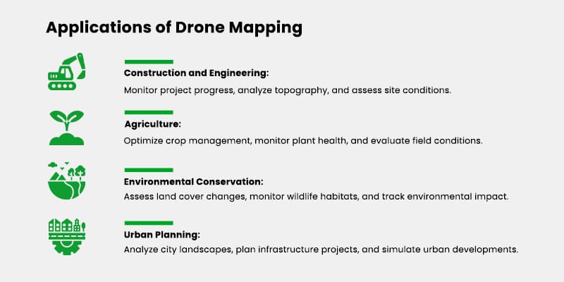
But having this as a fundamental feature can enhance your software’s versatility, making it available to not a few but multiple sectors like construction, agriculture, or environmental monitoring industries. So, teaming up with an expert vendor to incorporate this feature can ensure you create a drone 3D mapping software that makes the most of your drone data.
 3D Mesh Generation
It’s basically a process that converts point clouds into realistic mesh models. These 3D mesh models provide a detailed and immersive visualization of the surveyed area. So having your software generate 3D mesh models can enhance users’ understanding and exploration of various terrains.
This feature can be particularly invaluable for industries like architecture, urban planning, and virtual reality applications. So if you provide easy 3D Mesh Generation through your drone mapping software, many sectors can unlock a new visual representation and analysis level. They’ll become empowered to make informed decisions and communicate their findings effectively. At the same time, you’ll gain a huge user base. Ultimately, it will be a win-win.
 Elevation Mapping
Elevation Mapping gives the power to accurately measure and analyze the elevation changes in your surveyed area. Having this in your drone mapping software will allow users to navigate through all the nooks and crannies of the terrain. So it can be a real deal maker for people involved in construction, land management, or environmental planning to use your platform.
Think about it. With Elevation Mapping, people can plan their projects with precision. They’ll know exactly where the slopes are, how the contours flow, and the elevation variations that might trip them up. It will finally lead them to better-designed drainage systems, optimized infrastructure, and smarter land usage. But ensure you seek expert digital transformation services to equip your software with digital elevation mapping (DEM).
 Real-Time Data Visualization
People love having a bird’s-eye view to comprehend metrics. It’s like having a live feed of one’s current position! And that’s the point of adding real-time data visualization in your drone mapping software.
It will help users quickly spot any gaps or issues in the data and make on-the-spot adjustments. No more waiting until the end of the project to find out if everything went smoothly. Real-time data visualization will give users instant feedback and help them ensure they’re on the right track with their mapping data.
 Cloud storage
It’s old fashion to manage tons of data on local devices. Rely on cloud integration services to secure your users’ mapping data in one place. Give them a virtual warehouse for their maps and reports. And the best part? Making data accessible anytime and anywhere to users will not be your headache anymore. Cloud sharing will let users share maps with clients or team members swiftly. It will make your drone mapping software not only highly functional but also great for streamlining internal operations for companies.
Though these were some of the most sought-after features of mapping software that uses drones, you can always have more room for tailored features if you partner with a vendor providing custom enterprise software development services. On that note, let’s move on to the development process so that you can understand how to make a feature-rich and advanced drone 3D mapping software a reality.
Drone Mapping Software Development: Key Steps
If you want to develop software, the first step, in all honesty, is that you find a reliable software development company. Doing this will assure you and the other stakeholders that you are on the right path with your investment. Then, all you have to do is collaborate effectively on the below given crucial steps to ensure your drone mapping software turns out to be the same as per your vision.
 Gather Requirements and Identify Key Functionalities
First things first, you’ll have to engage with stakeholders to get a holistic business vision. Then, focus on understanding what functionalities you want your users to have.
Your features can be general, i.e., open to all sectors. Or, they can be industry-specific, i.e., for agriculture, construction, transportation, or more.
Consider these questions to determine the requirements:
- Who will be your end-users?
- What features are potential competitors providing?
- What’s the gap in the drone mapping software market?
- What’s trending for the potential clients? Etc.
 Architecture and Design
Once you know what’s best for your business and what user needs you want to address with your drone mapping software, it’s time to focus on architecture and design.
For infrastructure, consider parameters like scalability, performance optimization, and integration with APIs from mapping services, geospatial data providers, and other relevant sources. While doing this, remember your priorities should be your software’s functionality and data accuracy.
For design, sit with the creative team and plan the overall structure, data flow, and user interface. Here, remember that the software should be easy to navigate and interact with. Once the design is finalized, test it yourself and take user suggestions to ensure its high intuitiveness.
 Development and Testing
Now this is the most crucial stage.
You hire developers who code for your planned software architecture during this step. They fit in your required functionalities and integrate the necessary APIs.
If you rely on services that offer customizedable drone mapping software development, you’ll always have room for speculation regarding technology options. You’ll stay aware of industry best practices, reliable programming languages, and necessary algorithms.
If you want to know some technology options beforehand, consider the following table:
| Category | Technology Options |
| Front-end Frameworks | React, Angular, or Vue.js |
| Backend Technologies | Node.js, Python, or Java (for handling data processing, APIs, and server-side functionalities) |
| Database Systems | MySQL, MongoDB, or PostgreSQL (for efficient data storage and retrieval in the mapping software) |
| Mapping Libraries | Leaflet, OpenLayers, or Mapbox GL (to integrate interactive maps, layers, and geospatial functionalities) |
| API Development | Get custom APIs developed or go for existing mapping APIs like Google Maps API, Mapbox API, or OpenStreetMap API for map-related services. |
| Cloud Infrastructure | Amazon Web Services (AWS) or Microsoft Azure |
| Data Visualization | D3.js, Three.js, or WebGL |
| DevOps Tools | Consider DevOps tools like Docker, Kubernetes, or Jenkins for continuous integration, deployment, and automated testing of the software. |
Do not forget to keep a close watch on testing once you finalize the development. Participate in the various types of testing to ensure your software is ready for the next step.
 Iterative Development
Adopt an iterative approach to development. For this, you can consider a Minimum Viable Product (MVP).
When you launch an MVP, you provide only core functionalities to gather feedback and validation. Then, based on the feedback, you can continue to refine your drone mapping software development with emerging technologies and market trends.
 Deployment and Support
Finally, you’ll reach the deployment stage. It’s when you make your software public. But during this step, ensure you offer training materials, documentation, and technical assistance to help users maximize the software’s potential. Ask your team to continuously monitor performance, address user feedback, and release updates to ensure a seamless user experience.
Conclusion
Venturing into the realm of drone mapping software can open up a world of possibilities for your business. While the journey may seem daunting at first, this guide equips you with the necessary knowledge and insights to embark on a successful path in this field.
When you harness the power of drone technology and leverage the advancements in mapping software, you can conceive a lucrative business that will continue to bring you success in the years to come.
So, seize the opportunity, dive into the exciting world of drone mapping software development with us, and unlock your potential in this thriving industry.