

Gone are the days when people had to visit dangerous sites to survey a piece of land. With the discovery of drones, surveying has become safer and more efficient.
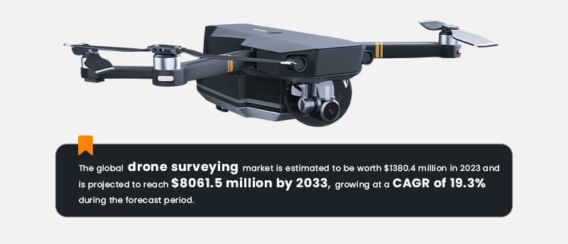
The advantages that drone surveying software brings to the table drive this continuous surge. Such solutions use drones to the best of their ability to capture vast areas with an aerial perspective, maneuverability, and high-resolution imaging.
So, if you’re planning for drone surveying software development, the future looks bright for you. With a strong business idea, you could feed the needs of multiple industries, like agriculture, mining, infrastructure inspection, etc. They’re waiting for you to provide professional surveying tools that ensure high-precision and reliable results.
Yes, it’s the right time to jump in. But wait before you seek services for custom enterprise software development. Dive into this blog to keep the necessary features and the development process handy.
Must-Have Drone Surveying Software Features
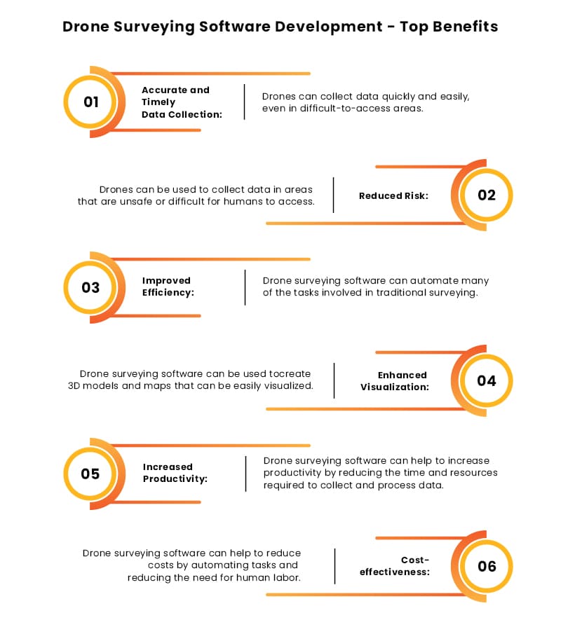
Drones can help people focus on precise data collection, georeferencing, and analysis through their surveying capabilities. But what if we tell you that you can make your app stand out with these prominent capabilities intact? Yes, that’s possible if you consider adding the below-given features to your software:
 Ground Control Point (GCP) Support
GCPs can deliver super accurate aerially captured measurements. With this as a feature in your drone surveying software, you can assure users that they’re making data-driven decisions. Plus, GCPs act as reference markers. They seamlessly blend data with other geospatial datasets and provide a standardized coordinate system. So, the level of accuracy of aerial data this single feature can offer is gold in industries like construction, land management, and infrastructure development.
So, let your users experience smarter planning and more insightful analysis with the power of accurate georeferencing. Whether they want to map land parcels, calculate volumes, or conduct topographic surveys, GCP support can ensure your app’s survey data is solid.
 Topographic Mapping
This feature is excellent if you want your drone surveying software to collect data regarding land’s contours, slopes, and other important details. With the nook and cranny of topography on screens, people can accurately assess the terrain and make informed project decisions.
That’s why topographic mapping can particularly benefit construction, urban planning, or environmental management companies. It can help them:
- Identify potential challenges
- Optimize designs
- Maximize land utilization
- Streamline operations
- Reduce risks
- Ensure successful project planning, etc.
Read More: How to Develop Drone Mapping Software? Features and Development Process
 Volume Calculation
Calculating the volumes of various objects of interest, such as stockpiles or excavation sites manually, can be a pain for companies. You can make them switch to accurate automatic calculations. All you need to do is partner with an AI development company that helps you integrate advanced algorithms into your drone surveying software.
The algorithms will help produce precise volume measurements. And this information is no less than a jackpot for various industries. Be it construction, mining, and agriculture, they can plan and manage resources effectively with accurate volume calculation. Furthermore, the feature can streamline the process and provide businesses with reliable and actionable data for decision-making.
 Geodetic Surveying Support
Another feature to consider for your drone surveying software is geodetic surveying support. As the name suggests, it helps users ensure geodetic surveying principles and reference systems. How? It aligns survey data precisely with established control points, ensuring accuracy and reliability.
You can think of it as a virtual GPS system, enhancing the precision of measurements taken by your software. Not just that, but it also aids informed decision-making, precise planning, and confident data analysis. So whether your users work on tough terrains, on infrastructure projects, or study the environment, this feature can be their trusted companion.
 Coordinate System Transformation
Looking for a survey data translator for your drone surveying software? Look no further! With this feature, your drone surveying software becomes compatible with existing geospatial datasets and project requirements.
So, having this will enable users to access various data sources. Their team collaboration will become smooth as they use different coordinate systems. Data sharing will be as easy as pressing a few buttons. Thus, it helps save time, ensure smooth project execution, and enable users to unlock the full potential of your drone surveying software.
 Real-Time Data Transmission
Want users to have instant analysis and on-site decision-making? Consider having real-time data transmission in your drone surveying software. It will let users survey data transmitted from the drone to the software in real-time. Yes, this means no need for time-consuming data retrieval and processing.
So, the decision-making based on the latest data will be fast, enhancing productivity and efficiency. Whether it’s monitoring project progress, assessing survey accuracy, or identifying potential issues, the feature can offer actionable insights when they matter most.

Drone Surveying Software Development: The Steps
To develop your software, ensure you have a reliable software development company by your side that aligns with your vision. Partnering with an experienced team will offer you multiple benefits. For instance, you can have access to a pool of resources, latest market trends, next-gen technologies, etc. Then, collaborate effectively on the following essential steps to ensure you meet your business requirements.
 Step 1: Requirement Gathering
First things first, define the scope of your drone surveying software. For this, you should engage with the potential stakeholders, including surveying professionals and potential end-users. With all that set, you need to define:
- What’s your aim?
- What’s going to be your target market?
- What features are necessary for the market you target?
- What are the gaps in the market that your tool can fill in? Etc.
This clarity will guide the development process and ensure the software aligns with your specific goals and meets the needs of your intended users.
 Step 2: Project Planning and Documentation
Now is the time for your chosen digital transformation services to join forces. The vendor you select will lay down the foundation for your drone surveying software.
So, this phase, it’s all about collaboration and communication. You’ll work closely with the development team to create a detailed project plan and documentation outlining every software development journey aspect. Together, you could define the timelines, milestones, and deliverables you want to achieve.
The goal here is to ensure that everyone involved is on the same page and clearly understands what needs to be done and when. It’s like setting guidelines that help during the entire development process. With proper documentation, both you and the development team can track progress, manage expectations, and stay organized throughout the project.
 Step 3: Focus on User Interface and Experience (UI/UX) Design
This step is all about working closely with the design team to create a visually appealing and user-friendly interface for your drone surveying software.
It’s about ensuring that your software is easy to navigate, visually pleasing, and perfectly tailored to meet the needs of your end users. The UI design focuses on aesthetics, while the UX design ensures a seamless and intuitive user experience.
Prioritize design to set the stage for your software to look great and remain highly useful for users.
 Step 4: Development and Testing
It’s time to kickstart the drone surveying software development after coming to common ground with the documentation.
Establishing a smooth line of communication with the development team during core development is important. For this, ensure you:
- Track the progress of the software
- Stay updated on the development timeline
- Address any concerns
- Provide valuable feedback, etc.
Remember, collaboration is key during this phase. It’ll help ensure the drone surveying software meets your vision and requirements.
But we’re not done just yet! Thorough testing is also a crucial part of the drone software development process. The development team will conduct tests at various stages to identify and squash any pesky bugs or issues that may arise. Testing ensures that the software functions smoothly and provides accurate results. Moreover, it helps to refine the software, enhance its performance, and ensure it delivers the expected functionality.
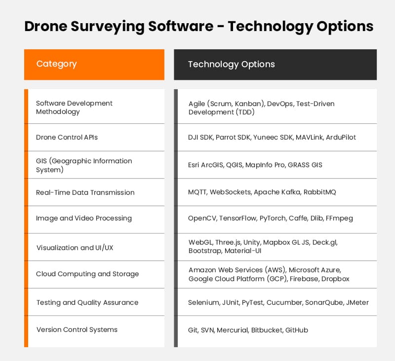
Refer to the below-given table to understand what technology options you’ll most likely have during this stage.
 Step 5: Deploy MVP
After the development and testing phases, it’s time to get your drone surveying software ready for action.
Deploying an MVP involves making the software available to your intended users or a selected group of early adopters. It’s an essential step that allows you to gather valuable feedback and insights to make those final tweaks to your product.
The development team will work closely with you during this phase to ensure a smooth deployment process. The team will set up the necessary infrastructure, servers, and configurations to make your MVP accessible. Besides this, ask them to prepare any required documentation or user guides to optimize the software’s user experience.
As you release your MVP, monitoring its performance and gathering user feedback closely is important. Doing this is pivotal for knowing how your software is meeting user needs. Feedback also helps identify areas where your software can improve and prioritize future development efforts.
 Step 6: Ensure Maintenance and Support
Your job doesn’t end with the deployment of your drone survey software. You should follow up with long-term maintenance and support. And for this, you’ll need a dedicated team to monitor the software’s performance, collect user feedback, and address any bugs or glitches. Relying on professionals will ensure you regularly update and look out for patch releases to keep your software compatible and secure.
If you wish to go further with maintenance, consider offering a helpdesk or customer support system to assist users promptly. Or, you can provide manuals and guides in your application or website to help users navigate whenever they face an issue. Lastly, prioritize user feedback and conduct performance to improve your software continuously.
Support and maintenance are particularly important for drone surveying software as drone technology is relatively new and complex for people.

Closing Lines
As a business, if you consider developing drone surveying software, it can offer a huge competitive edge. Incorporate unique features and functionalities specific to your target industry or use case to stand out in the crowd. Additionally, following the ideal development process with a reliable vendor like Matellio will enable you to attract a niche user base and increase market appeal. Doing this will also help you gain other essential services like enterprise solutions, cloud integration, and more in one place.
Remember this step is essential to develop tailored software that addresses specific user needs and pain points. All this done right, you can enhance your software’s value proposition and position your company as a trusted and innovative business.