

As the demands on land use grow, from agriculture and forestry to urban planning and conservation, the need for comprehensive and intuitive solutions becomes paramount. Land management software steps in as a game-changer, empowering organizations to navigate the intricate web of tasks associated with land administration.
Land management, a critical aspect of sustainable development, involves the efficient administration, conservation, and utilization of land resources. As technology advances, property management software development plays a pivotal role in streamlining processes, enhancing decision-making, and promoting environmental sustainability.
In this blog, we delve into the realm of land asset management software – a powerful tool that transcends traditional methods, offering efficiency, precision, and sustainability in the stewardship of our lands.
Land Management Software: What & Why?
Land management software is central to the administration of land-related data and processes. It helps organize and maintain information about land parcels, ownership, transactions, and legal documentation.
The land management system software aids in optimizing the use of land resources by providing tools for planning and decision-making. This includes features for zoning, land use mapping, and assessing the environmental impact of land-related activities.
Land management software development is for centralized repository for diverse land data, including cadastral information, land tenure details, land use policies, and historical records. Efficient data organization is crucial for accurate decision-making.
Role of Land Management Software in Optimizing Land-Related Processes
Land development project management software is pivotal in optimizing various land administration, use, and planning processes. Here are critical aspects of enterprise software development that highlight its crucial role:
Efficient Data Management
Land acquisition management software provides a centralized database for storing and managing diverse land-related information, including ownership records, cadastral data, and land use details. It also ensures data accuracy and integrity through standardized formats and secure storage.
Title and Ownership Records
It facilitates the automation of title issuance, transfers, and updates, reducing paperwork and minimizing errors. Land management software enables efficient tracking of ownership history, making it easier to verify and update records.
Cadastral Mapping and GIS Integration
Land management software integrates with GIS (Geographic Information System) to accurately map. Supports spatial analysis for informed decision-making in land-use planning and development.
Permitting and Zoning
It automates permit application and approval processes, reducing delays and enhancing transparency. Land lease management software helps enforce and ensure compliance with zoning regulations and land-use policies.
Land Valuation and Tax Assessment
Land acquisition management software utilizes AVM for accurate and fair land valuations. Streamlines the assessment of property taxes based on updated and reliable data.
Workflow Automation
Land management software automates routine tasks, reducing manual effort and improving overall workflow efficiency. It provides alerts for critical events, ensuring timely responses and preventing bottlenecks.
Land Use Planning
Land management software allows for scenarios to assess the impact of different land-use plans. It facilitates public participation in the land-use planning process through online platforms.
Environmental Impact Assessment
Land management software incorporates tools for evaluating and managing the environmental impact of land development projects. Ensures adherence to ecological regulations during land-use changes.
Document Management and Records Retention
Transitions from paper-based to digital document management software, reducing physical storage needs. Enforces policies for secure storage and timely disposal of records.
Security and Compliance
Implements robust access controls to protect sensitive land-related data. Land management software ensures compliance with regulatory requirements in land contract management software.
Collaboration and Communication
Land management software facilitates communication among various stakeholders involved in land-related processes. Land management software development uses public access to certain land-related information, fostering transparency.
Also Read: Real Estate Lease Management Software Development – A Complete Guide
Features to Consider During Land Management Software Development
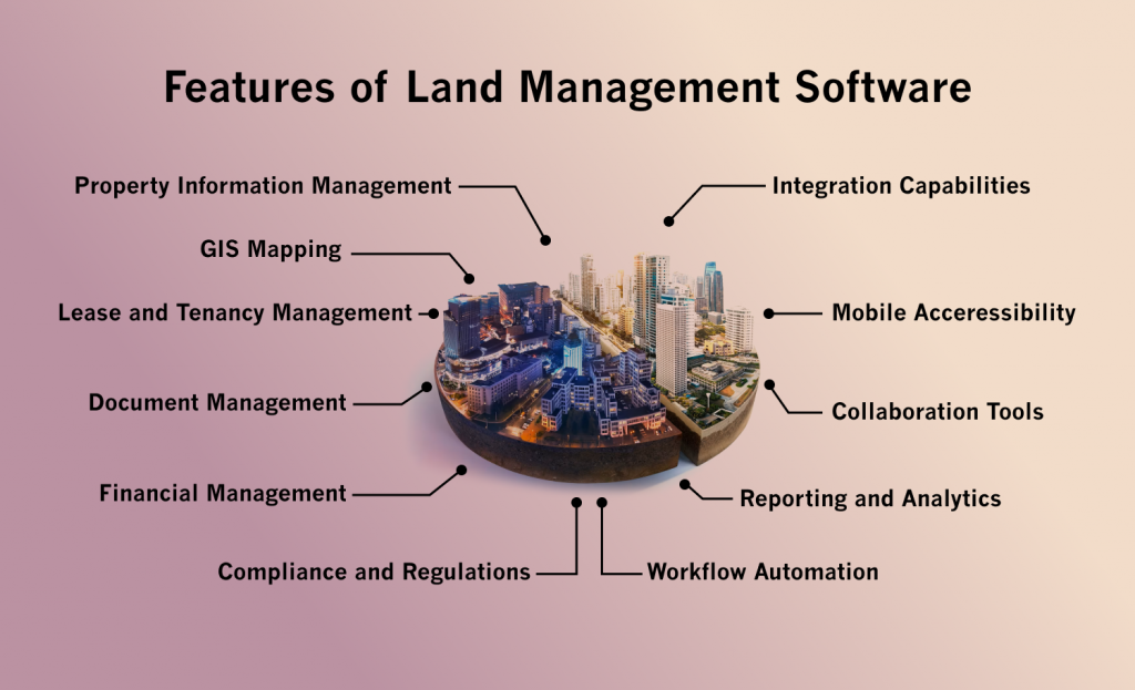
Land management software is designed to streamline and optimize various land, properties, and real estate tasks. Its features are tailored to address the complexities of overseeing land assets efficiently. Here are key features to consider during enterprise software development:
 Property Information Management
 Land management software helps to maintain a comprehensive database of property information, including ownership details, legal descriptions, boundaries, and related documentation. Track and manage property titles, deeds, and associated legal documents.
 GIS Mapping
 It utilize Geographic Information System (GIS) capabilities for mapping and visualizing land parcels, boundaries, and relevant geographical features.
Land management software overlay various data layers such as zoning, environmental factors, and utilities for comprehensive spatial analysis.
 Lease and Tenancy Management
Land management software helps in manage lease agreements, including terms, conditions, and payment schedules.
It also helps to schedule and automate lease renewals and rent adjustments.
 Document Management
Land management software helps to store and manage digital copies of land-related documents, such as contracts, surveys, and permits. With the help of this feature of land contract management software, you can track revisions and changes to documents, ensuring accuracy and compliance.
 Financial Management
 Land management software helps to monitor income from land assets, including rent, royalties, and other financial transactions—track expenses related to property maintenance, taxes, and other associated costs.
 Compliance and Regulations
 Land management software helps to stay compliant with indeed local and federal regulations regarding land use, zoning, and environmental requirements. You can receive alerts and reminders for regulatory compliance deadlines.
 Workflow Automation
Land management software automate routine tasks such as lease renewals, payment processing, and document approvals.
You can receive alerts for critical events, deadlines, or pending tasks.
 Reporting and Analytics
 It generate customizable reports on property performance, financials, and compliance. Land management software utilize digital transformation services to gain insights into land usage patterns, occupancy rates, and financial trends.
 Collaboration Tools
 It helps to define access levels for different users within the organization. Land management software facilitate communication and collaboration among stakeholders, like property managers, legal teams, and investors.
 Mobile Accessibility
 It access and manage land data remotely through mobile devices. Capture and update data in real-time while in the field, improving efficiency.
 Integration Capabilities
Land management software can seamlessly integrate with accounting software, ERP systems, or other enterprise applications. It provide APIs for custom integrations with third-party tools and services.
Also Read: Real Estate Marketplace Software Development – A Comprehensive Guide

Benefits of Land Development Project Management Software
Land management software development offers a range of benefits for organizations and individuals involved in managing land, properties, and associated resources. Here are some key advantages of this enterprise software development for land management:
Efficient Data Organization: It centralizes information related to land parcels, ownership details, and land use regulations. This improves data organization and accessibility, reducing the likelihood of errors and discrepancies.
Enhanced Decision-Making: It provides comprehensive data analytics and reporting tools, empowering stakeholders to make informed decisions. This includes insights into land values, usage trends, and potential risks.
Streamlined Operations: Land management software automates routine tasks such as property assessments, tax calculations, and document generation. This automation improves efficiency, reduces manual errors, and saves time for land management professionals.
Regulatory Compliance: It helps to ensure compliance with local, regional, and national land use regulations and zoning laws. This is crucial for avoiding legal issues and ensuring that all activities align with established guidelines.
Real-time Access to Information: It enables stakeholders to access real-time information about land assets, property transactions, and ownership details. This ensures that decisions are based on the latest data.
Optimized Land Use Planning: Land management software supports effective land use planning by providing tools to analyze and visualize spatial data. This helps identify optimal land use scenarios, minimize environmental impact, and promote sustainable development.
Improved Collaboration: It facilitates collaboration among various stakeholders involved in land management, including government agencies, developers, surveyors, and environmentalists. Enhanced communication ensures that indeed everyone is on the same page.
Financial Management: Land management software assists in budgeting, financial planning, and revenue tracking related to land assets. This is particularly valuable for local governments and organizations that rely on land-related income streams.
GIS Integration: Land management software helps in integration with Geographic Information System (GIS) technology and other cloud integration services, enabling spatial analysis and mapping. GIS integration enhances visualization capabilities, helping users understand the geographic context of land-related data.
Environmental Monitoring: It supports monitoring and managing environmental aspects of land, such as vegetation, water quality, and wildlife habitats. This is essential for sustainable land management practices.
Risk Mitigation: It identifies potential risks associated with land assets, such as legal issues, encroachments, or environmental hazards. Early identification allows for proactive mitigation measures.
Customer Service Enhancement: It improves customer service by providing landowners, developers, and the public with easy access to information. This transparency fosters trust and satisfaction among stakeholders.
Security and Data Integrity: Land management software implements robust security measures to protect sensitive land-related data. Ensures data integrity by maintaining accurate records and preventing unauthorized access.
Adaptability and Scalability: Land management software adapts to evolving technology and regulatory changes. Scalability ensures that the software can indeed handle growing volumes of data and users as the organization expands.
Types of Land Management Software
Land management software encompasses a variety of tools designed to assist in the planning, monitoring, and administration of land-related activities. These applications cater to different aspects of land management, providing solutions for various industries. Here are some common types you can consider during property management software development:
Geographic Information System (GIS) Software
GIS software is used to capture, store, analyze, and present spatial or geographic data. It aids in visualizing and interpreting land-related information.
Applications: Urban planning, environmental management, natural resource monitoring, and land use planning.
Land Information Management System (LIMS)
LIMS focuses on managing and organizing information related to land parcels, titles, ownership records, and associated documentation.
Applications: Government land registries, real estate management, and land parcel databases.
Real Estate Management Software
Tailored for real estate professionals, land lease management software assists in property management, lease administration, and real estate portfolio optimization.
Applications: Property management companies, real estate agencies, and corporate real estate departments.
Read More: Discover how real estate trust accounting software can streamline your financial management, ensure compliance, and enhance operational efficiency.
Land Surveying Software
It Facilitates the planning and executing land surveys, including topographic surveys, boundary surveys, and construction surveys.
Applications: Surveying firms, civil engineering projects, and construction site planning.
Land Use Planning Software
Land use planning software helps to develop and manage land use plans, zoning regulations, and comprehensive planning documents.
Applications: Municipal planning departments, regional planning organizations, and urban development authorities.
Conservation Management Software
It supports the planning and monitoring conservation efforts, including wildlife habitat preservation, ecosystem management, and environmental conservation.
Applications: Conservation organizations, national parks, and environmental agencies.
Forestry Management Software
This software helps to addresses the needs of forest and natural resource management, covering tasks such as timber inventory, logging operations, and forest planning.
Applications: Forestry companies, government forestry departments, and environmental NGOs.
Agricultural Land Management Software
Agricultural land management software targets farm and agricultural land management software development, providing tools for crop planning, yield monitoring, and resource allocation.
Applications: Farmers, agricultural cooperatives, and agribusinesses.
Water Resource Management Software
It focuses on efficiently managing water resources, including water quality monitoring, watershed management, and irrigation planning.
Applications: Water utilities, environmental agencies, and agricultural water management.
Facility Management Software
Facility management software manages land-based facilities by tracking maintenance, occupancy, and asset management.
Applications: Corporate real estate, facility management departments, and property management companies.
These land management software types are often specialized to cater to the unique requirements of the industries they serve. They are crucial in optimizing resource use, ensuring regulation compliance, and facilitating sustainable land practices.
Also Read: Real Estate Data Analytics Software Development: Features, Future Trends and Benefits
Use Cases of Land Management Software
Land development project management software plays a crucial role in efficiently handling various aspects related to land, resources, and property. Here are some critical use cases where land management software development is widely applied:
Real Estate Management
Land management software is extensively used in real estate for tracking and managing property information, ownership details, legal documentation, and transaction history.
Land Parcel Planning and Zoning
Urban planners and local authorities use oil and gas land management software to plan and zone land parcels, ensuring compliance with regulations, optimizing land use, and supporting sustainable development.
Land Records Management
Governments utilize land management system software to maintain accurate and up-to-date land records information. This includes ownership details, boundaries, and historical data.
Agricultural Land Management
Farmers and agricultural businesses use land lease management software to track crop rotations, monitor soil health, manage irrigation systems, and plan for optimal land utilization.
Natural Resource Management
Land asset management software manages natural resources such as forests, water bodies, and minerals. It helps in sustainable resource utilization, monitoring, and compliance with environmental regulations.
Land Conservation and Preservation
Conservation organizations use land acquisition management software to identify and manage areas for conservation, track biodiversity, and implement strategies for preserving natural habitats.
Infrastructure Development
Land lease management software is crucial in planning and executing infrastructure projects. It aids in assessing the impact on land, obtaining necessary permits, and indeed managing the construction process.
Land Use Policy and Compliance
Governments and regulatory bodies use land contract management software to enforce and monitor land use policies, ensuring enterprise software development meets zoning regulations and environmental standards.
Disaster Management and Emergency Response
During natural disasters, land asset management software helps authorities assess the impact on land, identify affected areas, and coordinate emergency response efforts.
Land Valuation and Taxation
Municipalities use land management software for assessing property values, calculating taxes, and managing tax records to ensure fair and accurate taxation.
Telecommunication Infrastructure Planning
Considering zoning regulations and environmental impact, telecom companies leverage land management software solutions for planning cell towers, antennas, and other infrastructure components.
Land Surveying and Mapping
Surveyors use land management software solutions to process survey data, create accurate maps, and generate reports for legal and planning purposes.
Community Development
Land management software supports community development initiatives by facilitating efficient land use planning and infrastructure development and ensuring that projects align with community goals.
Brownfield Redevelopment
In revitalizing contaminated or underutilized areas (brownfields), land management software solutions aid in planning redevelopment projects, assessing environmental risks, and coordinating cleanup efforts.
Oil and Gas Exploration
Land management software development is used in the oil and gas industry for managing leases, tracking exploration activities, and ensuring compliance with environmental regulations.
These use cases highlight the versatility of land management software solutions in various sectors, contributing to efficient and sustainable land utilization, resource management, and development planning.
Also Read: How to Develop Real Estate Lead Tracking Software?

Tech Trends in Land Management Software
Land management software continually evolves, adopting technological advancements to enhance efficiency, data accuracy, and decision-making processes. Several notable technology trends are shaping the landscape of land management software:
Geospatial Technology Integration:
Integrating geospatial technologies, like Geographic Information Systems (GIS), allows land managers to visualize, analyze, and interpret spatial data. This trend facilitates more informed decision-making by providing a spatial context to land-related information: improved mapping, land parcel identification, and spatial analysis for effective resource management.
Blockchain for Land Records:
Blockchain technology is being explored to enhance the security and transparency of land records. Blockchain’s decentralized and tamper-resistant nature can reduce fraud, streamline transactions, and establish trust in land-related data. Increased trust in land records, reduced fraud, and improved transparency in land transactions.
Cloud-Based Solutions:
Cloud integration services are transforming land management by enabling scalable, accessible, and collaborative solutions. Cloud-based land management software development allows users to access and update data in real-time from various locations. Enhanced collaboration, data accessibility, scalability, and reduced infrastructure costs.
Machine Learning and AI in Decision Support:
Machine learning (ML) and artificial intelligence (AI) are being employed for data analysis, predictive modelling, and decision support. These digital transformation services help identify patterns, predict land-use changes, and optimize resource allocation. Improved decision-making, resource optimization, and proactive management strategies.
Also Read: Top Custom AI Real Estate Solutions that Every Business Must Have.
Mobile Applications for Field Data Collection:
Mobile applications are becoming integral for field data collection, allowing land managers to gather information on-site. These apps often integrate with GIS and cloud integration services, ensuring real-time data updates. Increased efficiency in data collection, accuracy, and timely decision-making.
IoT for Remote Monitoring:
Internet of Things (IoT) devices, like sensors and cameras, are employed to monitor land and resources remotely. This data can include information on soil moisture, weather conditions, and wildlife patterns. Enhanced environmental monitoring, precision agriculture, and proactive response to changing conditions.
Augmented Reality (AR) for Visualization:
This can be particularly useful for urban planning, allowing stakeholders to experience proposed developments in a real-world context before implementation. Improved stakeholder engagement and more effective communication of development plans.
Data Security and Privacy Measures:
With the increasing digitization of land records, there’s a heightened focus on ensuring data security and privacy. Encryption, secure access controls, and compliance with data protection regulations are vital considerations. Mitigation of data breaches, increased user trust, and compliance with privacy regulations.
User-Friendly Interfaces and Dashboards:
Land lease management software incorporates user-friendly interfaces and dashboards, making it accessible to a broader audience. Visualization tools and intuitive interfaces simplify complex data for non-technical users. Increased user adoption, improved collaboration, and better accessibility for stakeholders.
Integration with External Systems:
Land management system software is increasingly designed to integrate seamlessly with various other enterprise systems, such as financial, legal, or environmental management systems. Streamlined workflows, reduced data silos, and improved overall organizational efficiency.
As the digital transformation services continue, land management software will evolve further to meet the changing needs of stakeholders in various sectors.
Development of land Management Software
Developing land management software involves a structured process to ensure the system meets the needs of users involved in land-related activities. Here are the property management development steps you need to consider:
 Define Requirements
 Gather requirements by consulting with stakeholders such as land surveyors, government agencies, and landowners. Identify key features, user roles, and functionalities required for effective land management. Analyze existing land management software solutions to identify market trends and understand user expectations. Determine if some unique features or improvements can be incorporated into your software.
 Design and Planning
 Create a detailed design that includes system architecture, database schema, and user interface mockups. Plan the enterprise software development phases and milestones and allocate resources accordingly. Develop a robust data model to represent various land-related entities such as parcels, titles, and ownership details. Design a database schema that ensures efficient storage and retrieval of land data.
 Start the Development
 Implement the software based on the approved design. Hire dedicated developers to build modules for features like land registration, parcel mapping, ownership tracking, and document management. If the land management software involves Geographic Information System (GIS) features, integrate mapping tools for spatial data representation.
Ensure compatibility with popular GIS platforms if needed. Implement secure user authentication and authorization tools to control access based on user roles. Integrate security measures to protect sensitive land data.
 Start the Testing
 Conduct thorough testing, including unit testing, integration testing, and user acceptance testing. Identify and resolve bugs, ensuring the software functions are as intended. Collect feedback from users and stakeholders to indeed identify areas for improvement. Iteratively enhance the software based on user needs and technological advancements.
By following these property management software development steps, you can create a comprehensive land management software solution that streamlines processes, enhances data accuracy, and improves overall efficiency in land-related activities.

Conclusion
Land management software catalyzes streamlining processes, enhancing transparency, and promoting responsible stewardship of our valuable land resources. From cadastral mapping to environmental monitoring, the impact of these tools is far-reaching, influencing industries ranging from agriculture to urban planning.
As we look to the future, the evolution of land asset management software is poised to continue, incorporating advancements such as artificial intelligence, machine learning, and the Internet of Things (IoT). These technologies promise to bring even greater automation, predictive analytics, and real-time insights into land-related decision-making.
It’s a testament to the transformative power of technology when harnessed for the greater good.
[sp_easyaccordion id=”45471″]